How to Determine Your Cook County Township
 When appealing your property taxes, you first need to identify in what township you live.
This may be straightforward if you live in Evanston or Oak Park, but where is Bloom, Bremen, Lake, and South Chicago? These latter examples do not relate to a particular suburb or Chicago neighborhood.
4 Methods
There are four ways to determine in what Cook County township you live:
- Check your property tax bill (top right) – get a copy mailed to you here
- Call the Cook County Assessor’s Office at (312) 443-7550
- Visit the Cook County Assessor’s Office website and enter your PIN or address
- View the township table below
Get your free property tax reduction estimate
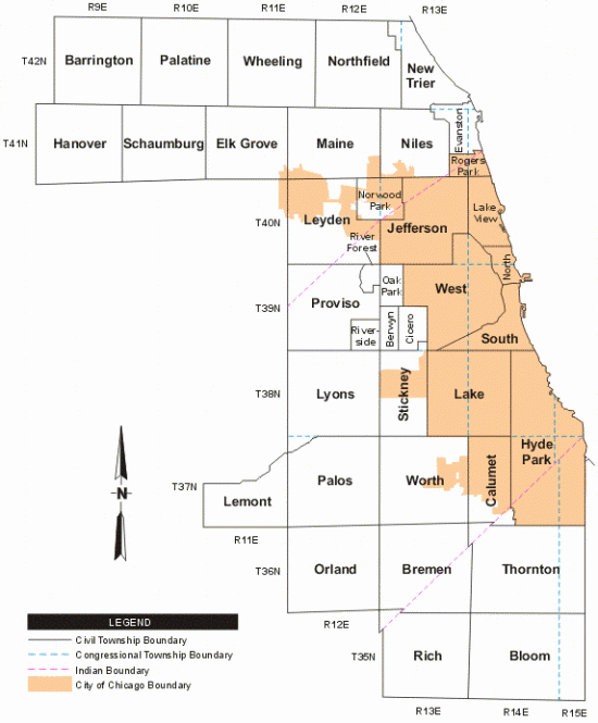
Below is a Cook County township map, followed by boundaries for each township.

Cook County Townships & Boundaries
| Cook County Townships | North Border |
South Border |
West Border |
East Border |
Cities, Towns & Villages |
|---|---|---|---|---|---|
| Barrington | McHenry/Lake County Line |
Central | Kane County Line |
Huntington |
|
| Berwyn | n/a (township borders match those of the suburb) | ||||
| Bloom | 183rd | 231st | Western Ave. | Indiana State Line |
|
| Bremen | 135th | 183rd | Harlem Ave. | Western Ave. |
|
| Calumet | 119th | 138th | Western Ave. | See Map |
|
| Cicero | n/a (township borders match those of the suburb) | ||||
| Elk Grove | Central | Devon Ave. | Rohlwing/I290 | Mount Prospect Road |
|
| Evanston | n/a (township borders match those of the suburb) | ||||
| Hanover | Central | Devon Ave. | Kane County Line |
Barrington Rd. |
|
| Hyde Park | Pershing (39th) | 138th | State St. | Lake Michigan / Indiana State Line |
|
| Jefferson | Devon Ave. | North Ave. | Harlem Ave. | Western Ave. |
|
| Lake | Pershing (39th) | City of Chicago Border |
City of Chicago Border |
State St. |
|
| Lake View | Devon Ave. | Fullerton Ave. | Western Ave. | Lake Michigan |
|
| Lemont | Bluff/DuPage County Border | 135th | Smith Rd. | County Line Rd. |
|
| Leyden | Devon Ave. | North Ave. | Harlem Ave. | Western Ave. |
|
| Lyons | 39th | 87th | County Line Rd. | Harlem Ave. |
|
| Maine | Central | Devon Ave. | Mt. Prospect Rd. | Harlem Ave. |
|
| New Trier | Lake County Line | Central/Evanston Border | See Map | Lake Michigan |
|
| Niles | Central | Devon Ave. | Harlem Ave. | Just East of McCormick Rd. |
|
| North Chicago | Fullerton Ave. | Chicago River (main stem) |
Chicago River (north branch) |
Lake Michigan |
|
| Northfield | Lake County Line |
Central | Des Plaines River / I-294 (approx.) |
Harms Rd. / Prairie St. |
|
| Norwood Park | n/a (township borders match those of the suburb) | ||||
| Oak Park | n/a (township borders match those of the suburb) | ||||
| Orland | 135th | 183rd | Will County Rd. (County Line) |
Harlem Ave. |
|
| Palatine | Lake County Line |
Central | Huntington Rd. / Eastern Ave. |
Wilke Rd. |
|
| Palos | 87th | 135th | Will Cook Rd. (Will County Line) |
Harlem Ave. |
|
| Proviso | North Ave. | 39th | I-294 | Harlem Ave. |
|
| Rich | 183rd. | 231st/Steger | Harlem Ave. | Western Ave. |
|
| River Forest | n/a (township borders match those of the suburb) | ||||
| Riverside | Cermak Rd | 39th St | 9th Avenue | Harlem Ave | |
| Rogers Park | Evanston Border | Devon Ave. | Kedzie Ave. | Lake Michigan |
|
| Schaumburg | Central | Devon Ave. | Barrington Rd. | Route 53 |
|
| South Chicago | Chicago River (main stem) |
Pershing (39th) | Chicago River (south branch) / Chicago Sanitary & Ship Canal |
Lake Michigan |
|
| Stickney | 65th | 87th | Harlem Ave. | Cicero Ave. (50) |
|
| Thornton | 138th | 183rd | Western Ave. | Indiana State Line |
|
| West Chicago | North Ave. | Pershing (39th) | Harlem Ave. | Chicago River / Chicago Sanitary & Ship Canal |
|
| Wheeling | Lake County Line |
Central | Wilke Rd. | Des Plaines River / I-294 (approx.) |
|
| Worth | 87th | 135th | Harlem Ave. | Western Ave. |
|


 Over 90% Success Rate on Property Tax Appeals & Protests
 No Up-Front Fees